Menu
Menu
Menu
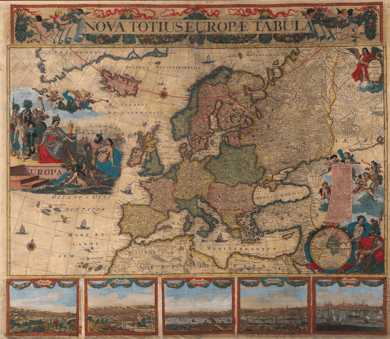
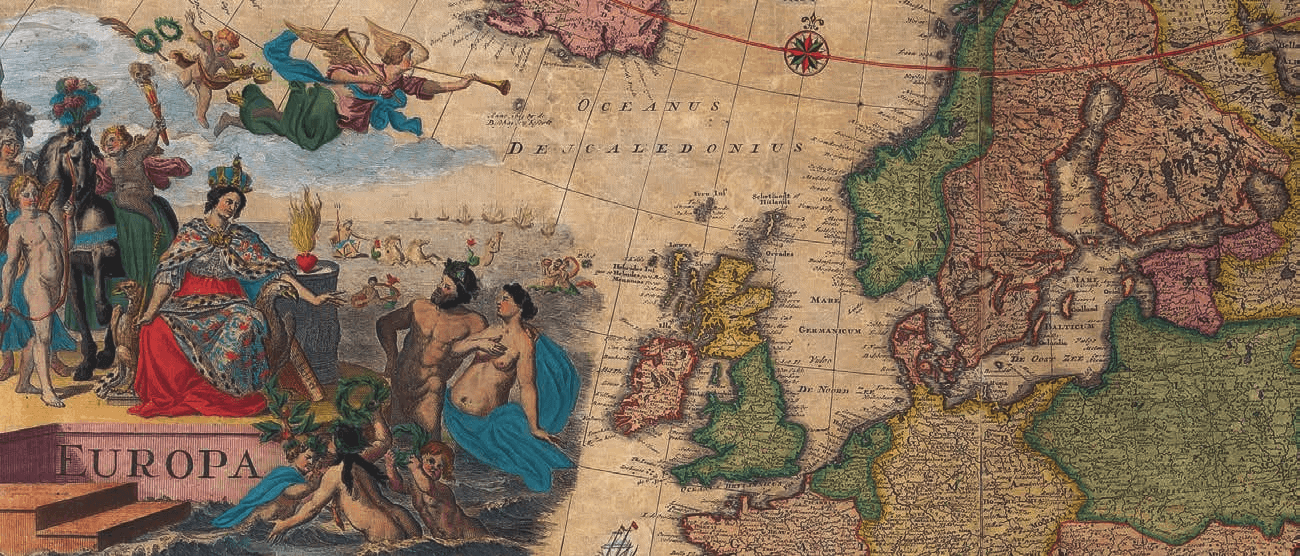
NOVA TOTIUS EUROPEA
TABULA
F Tideman.
G v d Gouwen fecie aquaforte
With views of Rome, Paris, London,
Seville. The title is on a banner held
aloft by putti with garlands of fruit.
In the cartouche upper right “Gedrukt
by Pet: Schenk Const en Caart Verkoper
Op de Vygendam Tot Amsterdam Met
Privilegie
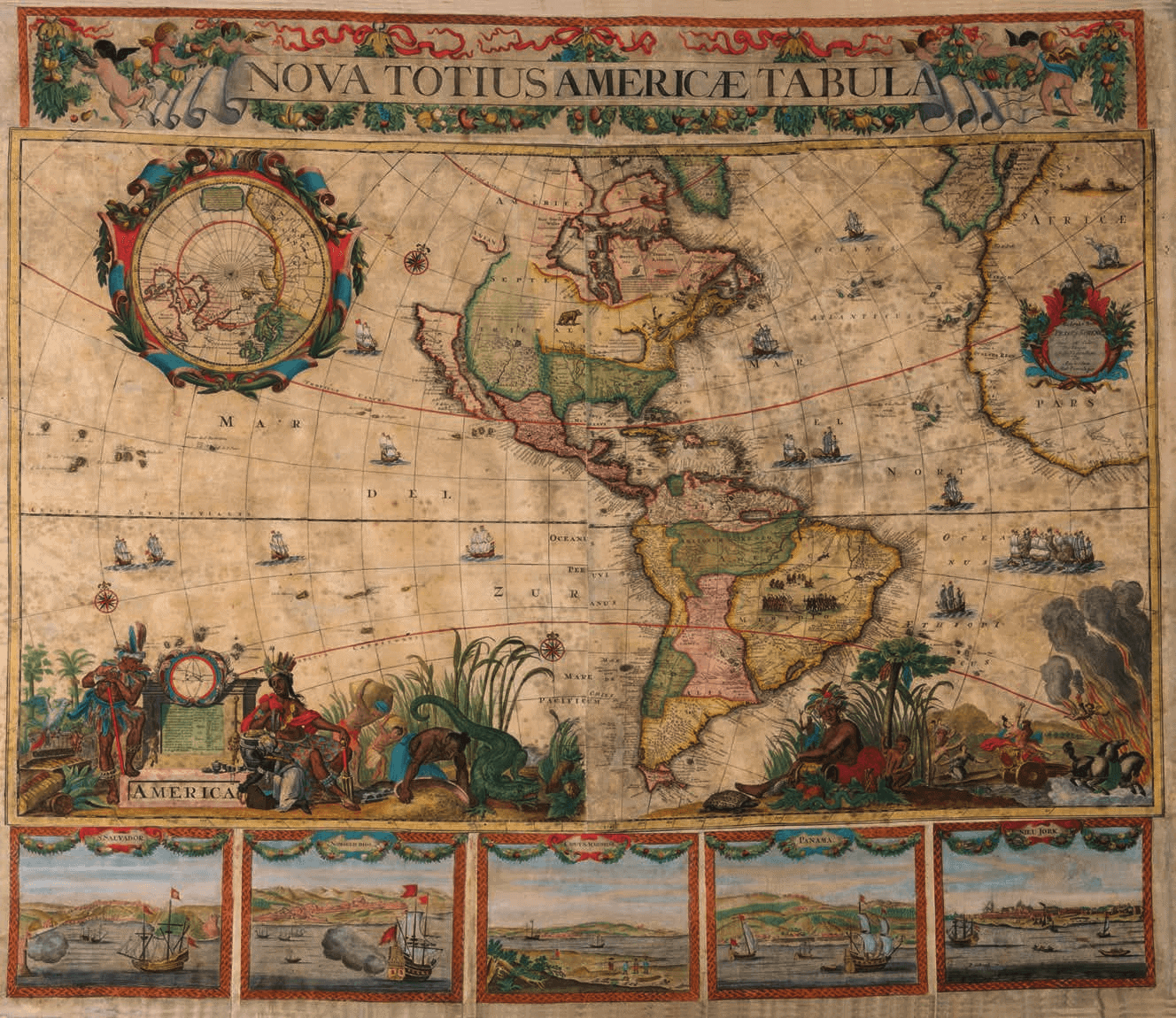
NOVA TOTIUS AMERICAE TABULA
F. Tideman, G v d Gouwe fecit With harbour views of S.Salvador, ‘Nombred Dios’ (near Panama), ‘Panama’, Nieu Jork’, ‘Caput S. Augustini’ (St. Augustine, Florida) The view of New York, signed by Schenk, is believed to be an unrecorded view of the city, after Visscher (or Blaeu), with the title reflecting the British capture of the city from the Dutch in 1674. The upper right corner features an inset of the Arctic Circle encompassed by a pageant of festoons, putti and deities. The map contained within hails from Henricus Hondius’ polar projection of 1636. Decoratively, the interior of South America is inhabited by scenes of native peoples and exotic animals, while numerous ships traverse the oceans, including two naval battles scenes in the Atlantic. Both of the lower corners feature vivid allegorical scenes. The scene on the left shows the personifications of war and knowledge flanked by vignettes of European encounters with indigenous warriors. The scene on the right depicts a procession of elaborately attired native peoples along with a Peruvian llama.
Set of four wall maps of the four continents, each on nine conjoined sheets:
The upper part with title border on two sheets, the maps of the continents on two sheets with decorative cartouches and five sheets of different harbour views in the lower part.
Copper engravings on paper with contemporary colour and
restorations as usual
Overall dimensions: 830 x 945 mm.
Amsterdam: Petrus Schenk, c. 1706
The elaborate cartouches were designed by Philip Tideman and engraved by Willem van Gouwen, who both worked for Visscher in the 1680s.
The maps largely derive from Jan Mathysz’s set of the continents published c. 1655, which were in turn based on Joan Blaeu’s world map of 1648 (Shirley 371).
Only three copies of the America map, one of Asia and one of Africa are recorded.
This is the only complete matching set known to exist.
Provenance:
Spain, private collection
Literature:
Koeman: Atlantes Neerlandici, vols. III, p.107, after 1706, is the address on the ‘ Vijgendam’ in Samson’s Atlas. Krogt, p. van der. ‘Advertenties voor kaarten, atlassen, globes [&c.]’. Ill. 195, p. 50. “1702, 30 mei / t’Amsterdam by P. Schenk, op de Beurssluys, zyn gedrukt en te bekomen: Hecatompolis, of 100 voorname steden des werelds … Nog alle de Kaerten van Italie in ‘t geheel en in deelen. Nog de vier deelen der wereld, zeer naeukeurig uitgewerkt, ware onder Asia zeer net is uytgebeeld volgens de allerbeste aftekeningen. Nog een Kartesiaensche Kaert der Hemispherien of Halfronden. En eyndelyk nog een kleyne Atlas van 27 Kaerten van Sanson, afgezet, voor 6 gulden. Alles uytgegeven met Privilegie.”
All such wall maps are great rarities. Technically difficult and very expensive to produce, they were issued in very limited quantities. Moreover, their great size and the manner in which they were displayed made them especially vulnerabe to damage, so that very few examples survive to the present day.
The maps of the four continents were mounted on canvas but the canvas has partly decayed over time. To ensure the maps’ preservation, they were carefully removed from the support so the original colours for the most part could be maintained and were then re-mounted on thin Japanese paper. Colours were enhanced where needed.
During the 17th century, when the Dutch Republic was at its economic and cultural high point, monumental wall maps played a unique and prominent role, which transcended the realm of cartography. They were considered to be among the ultimate signs of intellectual sophistication and affluence, notions of great import to the ruling mercantile class of the Netherlands. Johannes Vermeer, who prominently featured wall maps in several of his paintings, best captured their iconographic significance.
Petrus Schenk or Peter Schenk the Elder was born in 1660 in Elberfeld and moved to Amsterdam in 1675 to become a student of Gerard Valck. Petrus Schenk became a famous German engraver, cartographer and publisher, active in Amsterdam and Leipzig. He became court artist to the Elector of Saxony, August the Strong, a patron of the arts and architecture, in Dresden.
His second marriage was to Agatha Valck, the sister of the artist Gerard Valck, in 1687. They had three sons who became engravers. The Valck and Schenk families were united and were active as print sellers, publishers and printers of maps, atlases and architectural drawings as well as globes. In September 1695 a privilege was given to Schenk for printing maps copied from the Sansons.
His eldest son Peter Schenk the Younger was also a noted cartographer and art dealer who continued his father’s shop in Leipzig. His sons Jan and Leonard stayed in Amsterdam and probably continued their father’s workshop. His daughter Maria married Leonard Valck, the son of Gerard, who continued Gerard’s workshop.
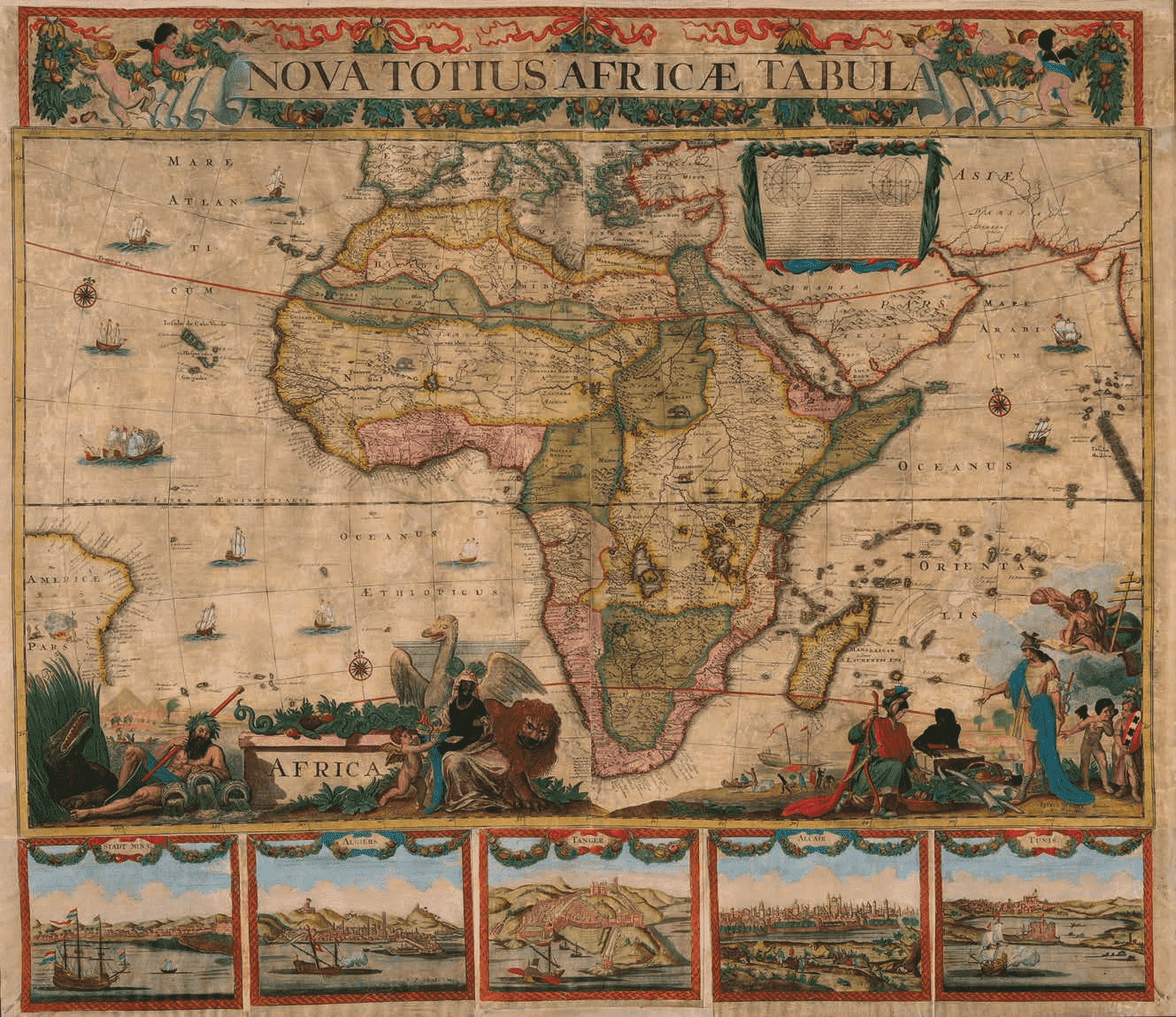
NOVA TOTIUS AFRICAE TABULA PETRUS SCHENK Excudet Met Previlegie
P. Tideman and G. van Gouwen, f.
With the harbour of Stadt Minae, Algiers, Tanger, Alcair, Tunis. The title is on a banner held aloft by putti with garlands of fruit; a second title is surrounded by allegorical figures representing Africa, the Nile and Mercury. Hidden among them are the signatures of Philip Tideman as the artist, Willem van der Gouwen as the engraver and Schenk as the publisher
NOVA TOTIUS AMERICAE TABULA
NOVA TOTIUS AMERICAE TABULA
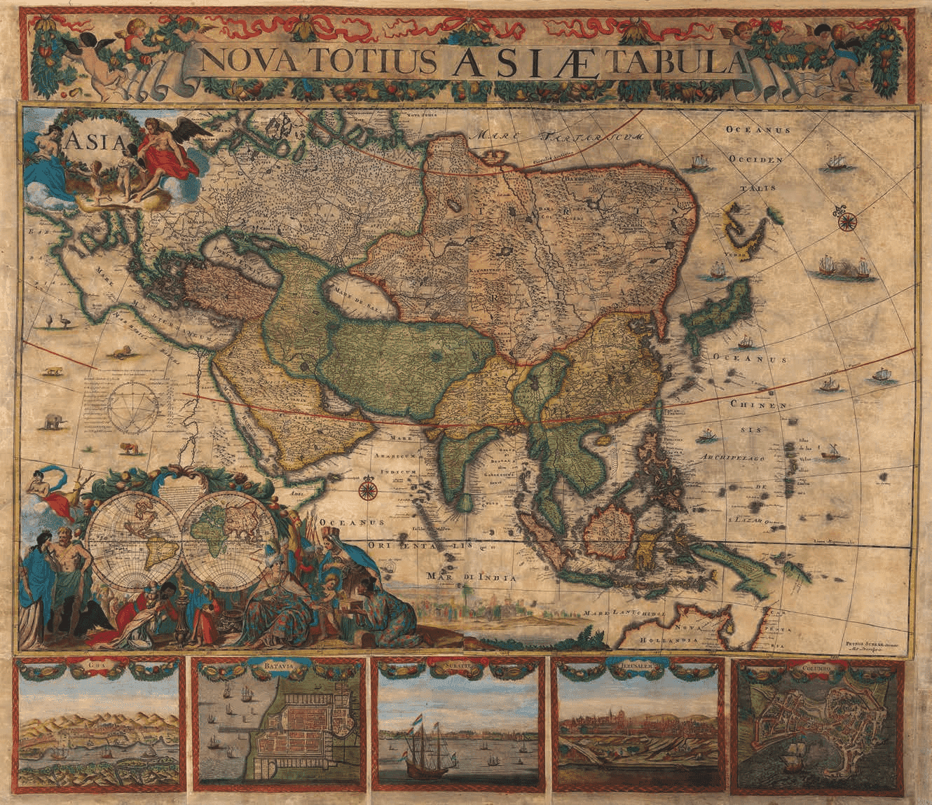
F. Tideman invent and G v d Gouwen fecit.
With harbour views of Goa, Batavia,
Suratte, Jerusalem, Colombo.
A large number of ports are indicated along the Persian Gulf;
among an early mentioning of Catara
(Qatar) Baharem (Bahrein)
Rob Kattenburg | Eeuwigelaan 6 | 1861 CM Bergen (NH) | The Netherlands | Tel. +31 (0)72 589 50 51 | Fax +31 (0)72 581 6031 | [email protected] | www.robkattenburg.nl